A strong earthquake with a moment magnitude of 6.9 struck the central Philippines late Tuesday night, Sept. 30, 2025. The quake hit at approximately 9:59 p.m. local time (21:59:43 PHT) with an epicenter about 10–17 km (roughly 6–10 miles) northeast of Bogo City, Cebu, and a shallow depth that increased the intensity of shaking felt on land.
Initial local reports described panicked residents rushing into the streets, temporary power outages in several towns, and visible damage to older stone structures. Authorities immediately warned residents in coastal areas to avoid the shoreline while they assessed the risk of a local tsunami.
Quick facts (for a sidebar):
- Magnitude: 6.9 (USGS / PHIVOLCS).
- Local time: 21:59:43 PHT, Sept. 30, 2025.
- Epicenter: ~10–17 km NE of Bogo City, Cebu.
- Depth: ~10 km (shallow).
Immediate impact and damage assessment
🚨A magnitude 6.9 #earthquake destroyed a #Catholic church in the Philippines, according to media reports.
— News.Az (@news_az) September 30, 2025
The tremors were felt most strongly on the island of #Cebu.
There are no casualty reports yet. Footage is being shared on social media. pic.twitter.com/FBkGiA4277
Structural damage
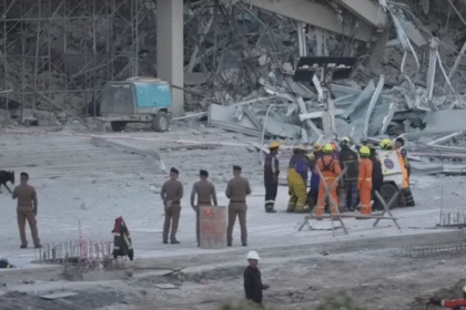
Early assessments and social-media-verified photos show damage concentrated in northern Cebu municipalities. One of the most visible hits was the partial collapse of the Archdiocesan Shrine of Sta. Rosa de Lima in Daanbantayan, a centuries-old stone church that sustained heavy damage. Local news and reporters on the ground also documented cracked walls, fallen masonry, and collapsed sections in several older buildings. Power outages were reported in multiple towns as crews inspected lines and transformers.
USGS exposure maps indicate tens of thousands of residents experienced severe shaking (Modified Mercalli Intensity ≈ VIII) in the hardest-hit coastal towns, while millions across the Visayas felt strong to very strong shaking. That combination—a nearshore epicenter and shallow depth—helps explain why older masonry and poorly reinforced structures suffered the worst damage.
Human response
Across Cebu and nearby islands, people reported instinctive safety responses: fleeing buildings, gathering in open areas, and coordinating with neighbors. Public events were interrupted—local accounts say a beauty pageant in Cebu City was stopped as the venue vibrated and patrons evacuated. Evacuation centers and temporary shelters were activated in towns with damaged homes, and emergency teams began door-to-door checks where access allowed. Initial emergency messages emphasized caution around unstable buildings and downed power lines.
Casualties: Initial wires reported no widespread, confirmed casualty totals in the first minutes after the quake; later local reporting indicated a small number of deaths in isolated towns as responders reached collapsed structures and sports venues—please check the latest NDRRMC/LGU situation reports for the confirmed toll before publishing.
Official response and safety measures
PHIVOLCS & tsunami advisory
PHIVOLCS (the Philippine Institute of Volcanology and Seismology) issued a local tsunami advisory for Cebu, Leyte, and Biliran provinces and warned of possible minor sea-level disturbances—roughly up to about one meter (≈3 feet)—urging residents to stay away from beaches and coastal structures until hazards were cleared. Director Teresito Bacolcol told reporters after the event that aftershocks and additional damage were expected and that monitoring would continue.
Emergency management on the ground
Local authorities, including provinces and city halls, went into action by implementing evacuation plans, closing some schools, and halting nonessential government work in the municipalities that were most affected in order that they could carry out structural inspections. Police, fire, municipal disaster teams, and utility crews were put into action for the search, rescue, and rapid damage assessment that followed the event. Before service was reestablished, buildings for provincial governments and public facilities were inspected for structural safety.
Geographic and scientific context
Why the Philippines is vulnerable
The archipelago sits squarely on the Pacific “Ring of Fire” and within the Philippine Mobile Belt, a complex zone of interacting plates and fault systems that make it one of the world’s most tectonically active regions. This geography explains why earthquakes—often accompanied by tsunamis and followed by damaging aftershocks—are a recurring hazard for millions of residents.
Earthquake characteristics
This event’s shallow hypocenter and strike-slip faulting nearshore amplified shaking intensity on land, particularly where older masonry dominates. USGS rapid assessments estimated several aftershocks above magnitude 5.0 in the hours after the mainshock—a pattern that elevates short-term risk to already-damaged structures.
Community preparedness and resilience
What systems were already in place
The Philippines has a legally mandated National Disaster Risk Reduction and Management framework, an active PHIVOLCS seismic network, and widespread community drill programs in schools and workplaces. Many local governments conduct earthquake drills and maintain quick-response teams; those systems reduce panic and improve initial life-saving actions (drop-cover-hold on, move to open areas, and avoid damaged buildings).
Gaps and where improvement is needed
On the ground, recurring issues still slow response and recovery: inconsistent enforcement of earthquake-resistant building codes (especially for older heritage and informal housing), limited access for people with disabilities at some evacuation centers, and shortages in regional stockpiles of medical supplies and heavy rescue gear. Retrofitting critical public infrastructure (schools, hospitals, and government buildings) remains a top priority in many provinces.
Recovery context and ongoing challenges
Compounding disasters
The quake struck a region already reeling from a recent storm that caused dozens of deaths and widespread outages. That overlap—typhoon damage plus earthquake impacts—stretches local resources: shelters are fuller, supply lines may be fragile, and repair crews are depleted. Humanitarian planning must account for concurrent needs: power restoration, shelter space, clean water, and trauma care.
Evacuation centers & help
Evacuation centers have been set up in municipal gymnasiums and schools; community groups and national agencies are organizing donation drives, but access to isolated barangays and small islands will be a logistical challenge if roads are blocked or ferries disrupted. Long-term displacement could become a reality for families living in heavily damaged houses.
Looking forward — lessons and preparedness
Preparing for “the big one”
Planners frequently warn that metropolitan areas like Manila face the risk of much larger earthquakes in the future; preparing for those scenarios means accelerating retrofits, updating population-risk maps, enforcing construction standards, and integrating social vulnerabilities into planning. The current event highlights why investments in resilient infrastructure pay off when shock hits.
Better disaster management
Improvements that matter now: faster public messaging and multi-channel alerts, inclusive evacuation planning for people with disabilities and the elderly, better local caches of medical supplies and temporary shelters, and international technical cooperation for heavy-rescue training. Integrating climate-resilience thinking—because storms and earthquakes can compound one another—should guide recovery spending.
Conclusion
On September 30, 2025, a 6.9-magnitude quake that struck near Bogo City, Cebu, was a harsh wake-up call: in the Philippines, earthquakes are not a matter of if but a matter of time. Prompt warnings, community drills, and rapid local action brought down the immediate damage to a minimum, but this incident unveiled the existing vulnerabilities—in heritage structures, in aged houses, and in the capacity of recovery systems—that will need not only financial resources but also people’s commitment for a long time. Officials are still tracking the aftershocks and giving out safety advisories; residents in the affected areas are advised to follow the updates of PHIVOLCS, NDRRMC, and their local government for the latest situational reports.


